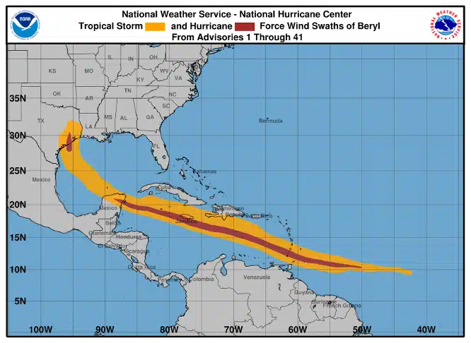
Grenada. The Yucatan. Texas. Hurricane Beryl tore through the Atlantic on a track that took it through the southern Lesser Antilles making its first landfall as a Category 4 on the island nation of Grenada, continuing south of Cuba until it made it’s second landfall as a Category 2 when it hit the Yucatan Peninsula finally making its final landfall at Matagorda, Texas as a Category 1 storm.
It set numerous records along the way. The first being that it was the earliest Category 5 storm on record since the beginning of satellite meteorology which began in 1966. Fastest intensification rate in 24 hours on record. Third lowest pressure on record (934 hPa) bested by Hurricane Emily in 2005 (929 hPa). Record rainfall totals to boot.
The storm lasted for 9.75 days throughout its lifecycle and caused billions of dollars in damage along the way, not including its post-tropical cyclone track through the Eastern part of the country.
In terms of damage totals, Jon Schneyer, the Director of Catastrophe Response for CoreLogic, said that the company is estimating $1.5 billion in damage in Grenada and the surrounding Windward Islands, up to $1 billion in Jamacia, Cayman Islands, and Mexico from glancing and direct hits, and up somewhere around $700 million to $1.5 billion in Texas.
“To see a major tropical cyclone east of the Caribbean in late June is almost unheard of. A Category 5 hurricane in early July has never been recorded,” said CoreLogic’s Chief Scientist Dr. Howard Botts.
Again, CoreLogic Hazard HQ Command Central estimates that total insured wind and storm surge losses in Texas will be between $700 million and $1.5 billion. This is an initial estimate that may be updated when more data becomes available. Millions are still without power in the Greater Houston Area as of the publication time of this article.
The estimated losses include damage to residential, commercial, industrial, and agricultural properties, including damage to contents and business interruption. The estimate includes demand surge. The losses do not include damage to offshore exposure.
According to CoreLogic’s models, insured losses could have mounted if the storm made landfall directly over a densely populated costal city such as Corpus Christi or Galveston. On the other hand, Beryl’s landfall over a relatively sparsely populated area like Matagorda Bay (90 miles southwest of Houston) meant the strongest winds impacted fewer properties resulting in a more manageable industry insured loss total.
“Hurricanes Idalia and Ian in 2023 and 2022 are good examples of why landfall location matters,” said Jon Schneyer. “Idalia, despite being a major hurricane at landfall, crossed the Florida coastline in the Big Bend region, a much less densely populated part of Florida. On the other hand, Hurricane Ian made landfall in southwest Florida over Cayo Costa near Fort Meyers, Florida. True, Ian was a stronger hurricane, but the difference in the estimated industry insured losses was large,” continued Schneyer. “Hurricane Ian caused tens of billions of dollars on insured losses, while Idalia caused just a couple billion, if even. Landfall location matters.”
Despite its location and all odds, Texas does not rank high among costal, hurricane-prone states due to its voluntary adoption of stringent building codes which are in excess of what is required of the 2000 International Residential Building Code.
But there are gaps in building code requirements; the areas surrounding Matagorda Bay and close to where Beryl made landfall are examples of smaller, unincorporated towns that may not have adopted modern building code standards. This could increase the risk for wind damage according to CoreLogic.
CoreLogic will provide more updates to preliminary damage estimates as the week and month goes on here.


