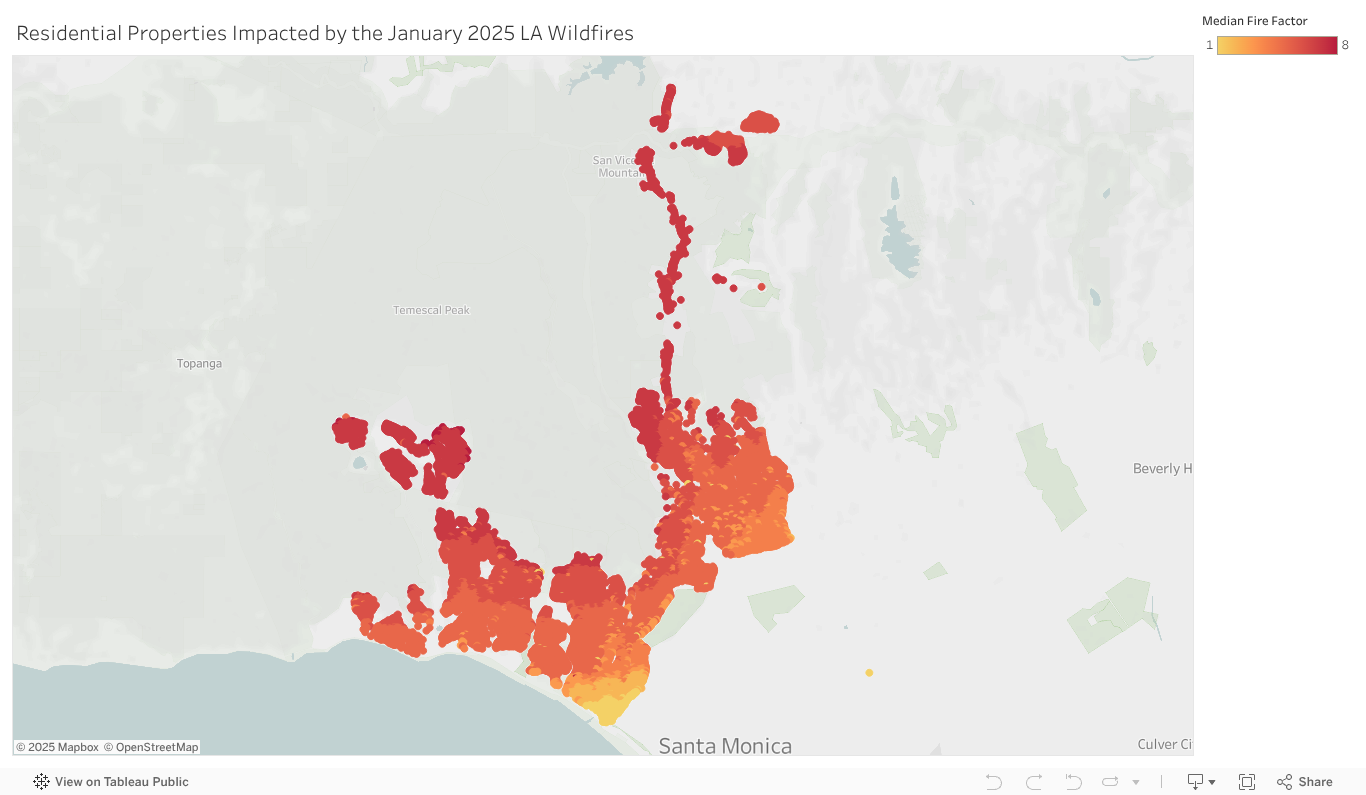


According to new data from Redfin, $51.7 billion worth of homes in the city of Los Angeles—or roughly 11,000 residential properties—were impacted by the wildfires in January. The report analyzes data from the Los Angeles City Council.
For the study, the Los Angeles City Council shared a list of 11,125 residential parcels in the city of Los Angeles that were inspected by the Los Angeles Department of Building and Safety after the wildfires. Redfin was able to match nearly 11,000 of those parcels with Redfin property value estimates as of December 2024—the month before the fires. Many, but not all, were completely destroyed by the fires. Most of the properties Redfin analyzed were single-family homes.
Most homes in this analysis were impacted by the Palisades Fire, which is estimated to be the third most destructive wildfire in California history, according to the California Department of Forestry and Fire Protection (Cal Fire). The fire made news for destroying homes in the high-end Pacific Palisades neighborhood, but many other areas were also devastated in January fires. Please note that this analysis excludes the impact of the Eaton Fire, which impacted the Los Angeles suburb of Altadena, meaning the total value of homes destroyed in the January fires far exceeds $51.7 billion.
Key Takeaways
- The typical impacted home had a value of $3.7 million prior to the fires
- Nearly 100 properties had a value of over $20 million prior to the fires
- The typical impacted home was built in 1957
- The typical impacted home was 2,916 square feet
- The roughly 11,000 impacted properties Redfin analyzed total 36.7 million square feet
- The typical impacted home has a First Street Fire Factor risk score of 5, or “major”
“The L.A. housing market is moving slowly after the fires,” said local Redfin Premier Real Estate Agent Greg Eubanks. “A lot of people who lost their homes are renting while they work through the insurance claim process, and haven’t figured out whether, when or where they’ll buy again. Some people whose homes burned in the Palisades have put their vacant lots up for sale, but those aren’t selling as quickly as the lots in Altadena because the price point in the Palisades is so much higher, which is a barrier for investors. It’s also a bit of a tough sell because infrastructure hasn’t been rebuilt yet—there are still no grocery stores.”
Fire risk scores are based on the latest available data from First Street and reflect their composite methodology, which incorporates both historical fire activity and forward-looking climate modeling. These scores are not time-stamped in the traditional sense, as they are designed to represent ongoing and projected risk rather than a fixed point in time.
Data from First Street reveals that Florida, Louisiana, and California are projected to account for 53% of all climate-related mortgage losses in 2025. First Street’s latest publication, The 13th National Risk Assessment: Climate, the Sixth “C” of Credit, presents an analysis of the growing influence of climate-related hazards—specifically flooding, wildfire, and hurricane winds—on mortgage market performance. The findings project that in severe weather years, events could lead to an estimated $1.2 billion in mortgage-related credit losses today, rising to $5.4 billion annually by 2035.
“It’s no longer sufficient to evaluate a borrower’s credit score alone,” said Matthew Eby, Founder and CEO of First Street. “Climate risk associated with the property itself has become a core determinant of creditworthiness. This marks a structural shift in financial risk assessment with major consequences for lenders, investors, and homeowners alike.”
Click here for more on Redfin’s report on the California housing market in the wake of January’s wildfires.